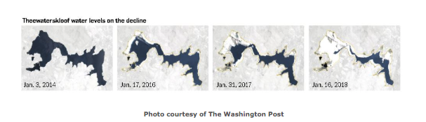
An article published by the Washington Post on Cape Town, South Africa and its diminishing reservoir water quantity due to climate-change-induced droughts featured a season rainfall map from the Climate Hazards Group InfraRed Precipitation with Station Data (CHIRPS) data set. Data compiled by team members of the UC Santa Barbara Climate Hazards Group display the "Wettest three month seasons in South Africa" ultimately working to prevent Day Zero, the shutting off of all tap water resources.
Originally published 2-12-2018
October 31, 2019 - 4:32pm