CHIRPS: Rainfall Estimates from Rain Gauge and Satellite Observations
CHIRPS v3
The Climate Hazards Center Infrared Precipitation with Stations (CHIRPS v3) is a 40+ year, high-resolution quasi-global rainfall dataset. It spans 60°N to 60°S and covers all longitudes, providing data from 1981 to near-present. CHIRPS v3 combines satellite-based thermal infrared rainfall estimates with in-situ station observations to produce a 0.05° gridded rainfall time series over land.
Two CHIRPS v3 products are available – a rapidly updated preliminary product and a final product. CHIRPS v3 Preliminary incorporates rapidly updated station observations and is available 2 days after the end of a pentad (on the 2nd, 7th, 12th, 17th, 22nd and 27th day of each month) – see the full list of CHIRPS v3 preliminary station sources here (https://data.chc.ucsb.edu/products/CHIRPS/v3.0/README-CHIRPSv3.0.txt). The CHIRPS v3 final product blends in best available station inputs and is produced once a month, typically on the third week of the following month. The dataset covers the global domain, with additional sub-domain products available for Africa and Latin America.
CHIRPS v3 is available in several formats (GeoTIFF, NetCDF, BIL, and COG) and multiple timesteps (daily, pentad, dekad, monthly and annual). CHIRPS is fundamentally a pentad and monthly product, and all other time-steps are derived from those. Based on two different ways of downscaling CHIRPS v3, we provide two different daily products: A reanalysis 'rnl' and a satellite 'sat' product. The 'rnl' uses daily precipitation from the ECMWF ERA Reanalysis v5 (ERA5) data product to partition pentadal CHIRPS v3 precipitation totals into daily amounts. The 'sat' uses daily precipitation from the NASA IMERG Late V07 data product (IMERG) to partition pentadal CHIRPS v3 precipitation totals into daily amounts. Here is a Google Earth Engine script that: 1. compares the two versions of daily CHIRPS v3 datasets and, 2. compares daily CHIRPS v3 totals with pentadal totals to show that the daily 'rnl' and 'sat' data add up to the same amount for the pentadal (here a 5-day) total https://code.earthengine.google.com/5a671f5001a319cc4307cc6c9cb1b45a
3. CHC Early Estimates: https://www.chc.ucsb.edu/monitoring/early-estimates. Regional rainfall maps (pngs and tifs) designed to support early warning of anomalous rainfall conditions that can impact agriculture and livelihoods. The CHC Early Estimates use a combination of CHIRPS, Preliminary CHIRPS, and the CHIRPS-GEFS 15-day forecast.
While many studies have shown that CHIRPS v2 performs well, we have identified and addressed an important shortcoming in CHIRP, the satellite-estimated component of CHIRPS. The regression formula used in CHIRP version 2 provided reasonable estimates and represented mean rainfall very well, however, it had a tendency to underestimate temporal precipitation variance.
The new CHIRP3 algorithm also estimates precipitation from geostationary satellite thermal infrared measurements of cold cloud duration (CCD), but version 3 performs better when it comes to estimating a wider range of precipitation values. This feature is especially useful for capturing high rainfall amounts of large, impactful, or out-of-season storms.
CHIRP algorithm basics:
CHIRP version 3.0
CHIRP version 2.0
CHIRP3 ∝ b2*CCD
Where
b2 = (CHPClim2 + 6) / (MeanCCD + 2)
CHIRP2 ∝ b0 + b1*CCD
Updates to the Climate Hazards Precipitation Climatology (CHPclimv2)
CHIRPS v3 uses a more reliable, high-resolution climatology, CHPclim2, which builds upon the foundation of CHPclim. The 1991-2020 CHPclim2 monthly climatology fields incorporate IMERG v6 Final inputs for enhanced precipitation estimates, and gauge-undercatch corrected station normals to account for systematic biases resulting in an increased mean rainfall. CHIRPS v3 incorporates substantially more climate normals compared to CHIRPS v2.
Station observations
1. Gauge-undercatch corrected station observations
A notable change in CHIRPS3 is the transition to gauge-undercatch corrected station observations. CHIRPS3 uses the Legates-Willmott correction factor to account for systematic biases in gauge measuring errors. When comparing CHIRPS3 to station observations, CHC recommends using gauge-corrected station data. The Legates monthly scaling grids are available for download at https://data.chc.ucsb.edu/products/CHIRPS/v3.0/diagnostics/legates-willm...
2. More station observations
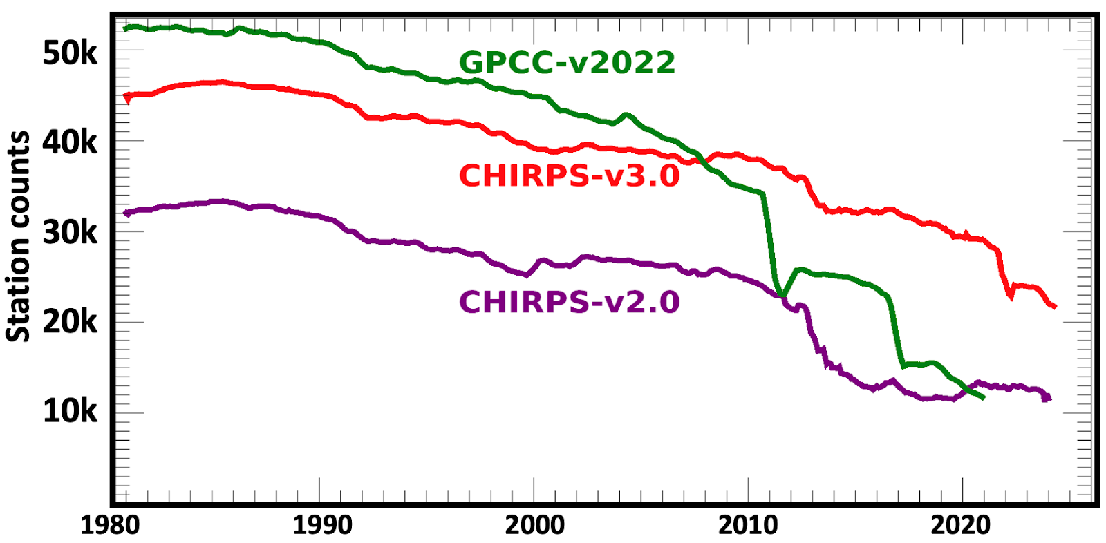
Through new collaborations between the CHC and partner institutions the number of sources and routinely updated station observations assimilated by CHC has increased substantially. CHIRPS v3 benefits from nearly four times more sources of gauge data compared to CHIRPS v2. This increased volume of observations significantly improves the spatial and temporal accuracy of rainfall estimates.
A comparison between CHIRPS2 and CHIRPS3 global annual mean station counts from 1981 to 2024.
The Climate Hazards Center currently maintains one of the largest rainfall station archives in the world.
Monthly station counts for CHIRPS v2.0, CHIRPS v3.0, and GPCC v2022 in thousands.
CHIRPS v3.0 replaces the widely used CHIRPS v2.0. To support users during this transition, the production of CHIRPS v2.0 will continue through 2026.
Climate Hazards Center Infrared Precipitation with Stations version 3 (CHIRPS3) Data Repository: https://doi.org/10.15780/G2JQ0P (2025). Data was accessed on [DATE].
Funk, C., Peterson, P., Harrison, L. et al. The Climate Hazards Center Infrared Precipitation with Stations, Version 3. Sci Data 13, 718 (2026). https://doi.org/10.1038/s41597-026-07096-4
CHIRPS3 is in the public domain, as registered with Creative Commons, and is licensed under a Creative Commons Attribution 4.0 International License . To the extent possible under the law, the Climate Hazards Center has waived all copyright and related or neighboring rights to CHIRPS3. This work is published from the United States.